CTHistory42
CTHistory42 OP t1_j5670ey wrote
Reply to comment by Squadbeezy in "Native Land Digital" is an indigenous-led, Canadian-based non-profit group seeking to raise awareness of where original Native American tribes owned property. They admit that this is a work in progress, not perfect, and seek corrections. Thought the CT map (with some NY) was quite interesting. by CTHistory42
Yup. At least 10,000 years - and maybe more
CTHistory42 OP t1_j55mgyb wrote
Reply to comment by dabasauras-rex in "Native Land Digital" is an indigenous-led, Canadian-based non-profit group seeking to raise awareness of where original Native American tribes owned property. They admit that this is a work in progress, not perfect, and seek corrections. Thought the CT map (with some NY) was quite interesting. by CTHistory42
I agree.
Also, there are so many references to Native Americans in town names, river names, street names - you name it!
CTHistory42 OP t1_j55lq8b wrote
Reply to comment by maxanderson350 in "Native Land Digital" is an indigenous-led, Canadian-based non-profit group seeking to raise awareness of where original Native American tribes owned property. They admit that this is a work in progress, not perfect, and seek corrections. Thought the CT map (with some NY) was quite interesting. by CTHistory42
Good questions and points all. I just posted it to get the discussion started - with the disclaimer that no one is saying it's perfect. Most of all, the group itself.
Here's the website for them: https://native-land.ca/
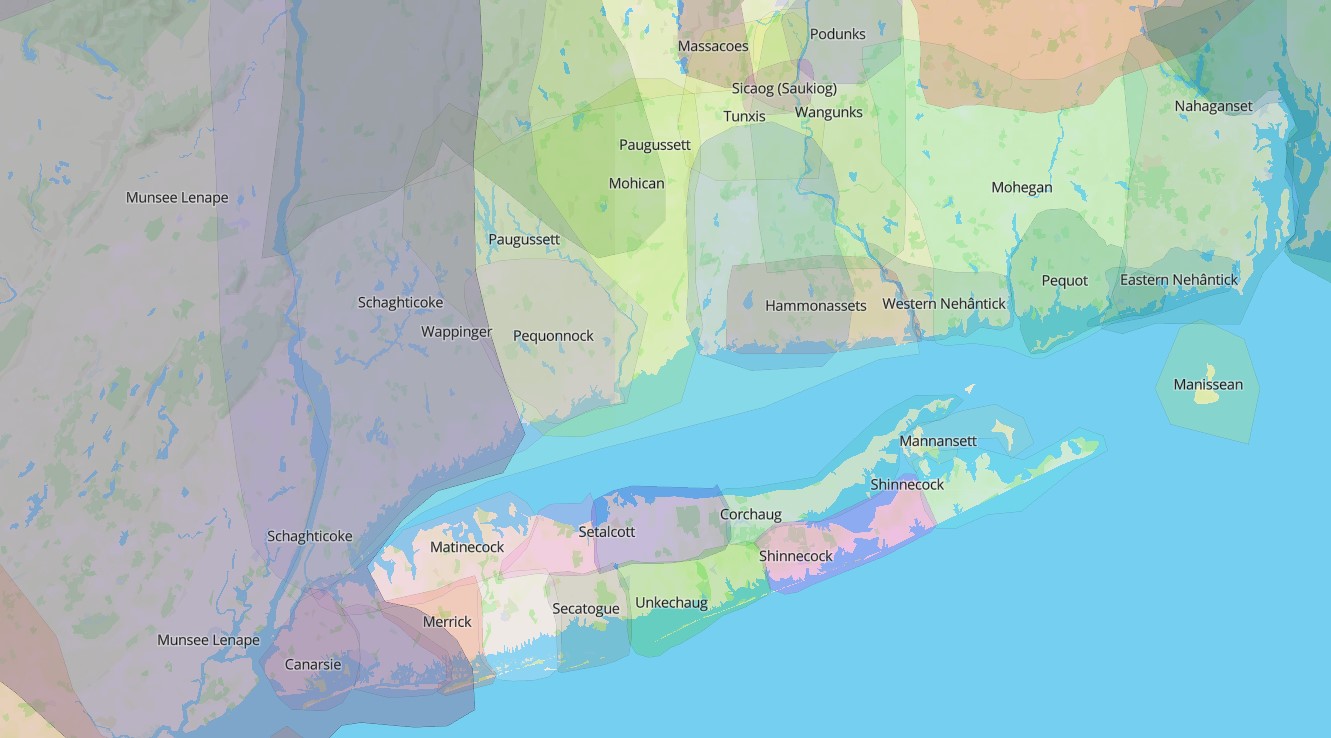 "Native Land Digital" is an indigenous-led, Canadian-based non-profit group seeking to raise awareness of where original Native American tribes owned property. They admit that this is a work in progress, not perfect, and seek corrections. Thought the CT map (with some NY) was quite interesting.
Submitted by CTHistory42 t3_10gx1la in Connecticut
CTHistory42 OP t1_j1l5u8q wrote
Reply to comment by Seegson-Synthetics in On Amazing Tales CT: This is where Revolutionary War soldiers kept the ammunition at Redding’s Putnam Park during 1778’s harsh winter. 3,000 soldiers suffered low pay, insufficient food and clothing. It became CT’s first state park. Find the podcast URL in the comments section by CTHistory42
Thanks a lot for the comment. Happy to pass along great stories about our state's incredible past.
CTHistory42 OP t1_j1l5rdo wrote
Reply to comment by pittiedaddy in On Amazing Tales CT: This is where Revolutionary War soldiers kept the ammunition at Redding’s Putnam Park during 1778’s harsh winter. 3,000 soldiers suffered low pay, insufficient food and clothing. It became CT’s first state park. Find the podcast URL in the comments section by CTHistory42
Glad you're enjoying the podcast. Much more history yet to uncover and discuss.
CTHistory42 OP t1_j1i1dqd wrote
Reply to comment by keepitupxxx in On Amazing Tales CT: This is where Revolutionary War soldiers kept the ammunition at Redding’s Putnam Park during 1778’s harsh winter. 3,000 soldiers suffered low pay, insufficient food and clothing. It became CT’s first state park. Find the podcast URL in the comments section by CTHistory42
;-)
CTHistory42 OP t1_j1hgpvk wrote
Reply to On Amazing Tales CT: This is where Revolutionary War soldiers kept the ammunition at Redding’s Putnam Park during 1778’s harsh winter. 3,000 soldiers suffered low pay, insufficient food and clothing. It became CT’s first state park. Find the podcast URL in the comments section by CTHistory42
You can hear the podcast story here: https://AmazingTalesCT.Podbean.com
 On Amazing Tales CT: This is where Revolutionary War soldiers kept the ammunition at Redding’s Putnam Park during 1778’s harsh winter. 3,000 soldiers suffered low pay, insufficient food and clothing. It became CT’s first state park. Find the podcast URL in the comments section
Submitted by CTHistory42 t3_zu7tyq in Connecticut
CTHistory42 OP t1_iy1ix2d wrote
Reply to comment by xj3kx in This satellite photo shows development in the Northeast. The one dark spot in CT-MA is a National Heritage Corridor (The Last Green Valley). Pristine woodlands, clear clean rivers. Half the size of the Grand Canyon; 85% undeveloped. Learn more on Amazing Tales CT: https://AmazingTalesCT.Podbean.com by CTHistory42
Glad to hear it!
CTHistory42 OP t1_ixytwia wrote
Reply to comment by readmeink in This satellite photo shows development in the Northeast. The one dark spot in CT-MA is a National Heritage Corridor (The Last Green Valley). Pristine woodlands, clear clean rivers. Half the size of the Grand Canyon; 85% undeveloped. Learn more on Amazing Tales CT: https://AmazingTalesCT.Podbean.com by CTHistory42
I'll take your point on the condition of the forest lands being in the same shape. Perhaps some loose wording there. Simply saying that a lot of the acreage is still untouched by housing/commercial development (85%). And, I was only talking about CT, not out west. But even there, sprawl is crazy. In the 1970s, it took me three hours of driving through barren (but absolutely gorgeous) nothingness along the base of the Rocky Mountains to get from Denver to Colorado Springs. Now, due to housing development, there's only about 15-20 minutes of true untouched nature between them (and that was 10-15 years ago - last time I drove it - could be even worse by now). American land use policy stands in stark contrast to Europe, where communities have concentrated centers and the land around them remains open for nature walks and other such purposes. Having lived in Switzerland for 7 years, my family experienced this regularly. Quite a refreshing difference. Not everybody needing/wanting a 1-2 acre plot of land with a house.
CTHistory42 OP t1_ixyt7jl wrote
Reply to comment by STODracula in This satellite photo shows development in the Northeast. The one dark spot in CT-MA is a National Heritage Corridor (The Last Green Valley). Pristine woodlands, clear clean rivers. Half the size of the Grand Canyon; 85% undeveloped. Learn more on Amazing Tales CT: https://AmazingTalesCT.Podbean.com by CTHistory42
It's supposed to be the one dark spot along the coastline. Inland sections tend to be darker, more remote and less developed. The point of the 36 CT and MA communities in The Last Green Valley is that it's a National Heritage Corridor with 700k acres, of which 85% remain undeveloped and in pristine condition. If Litchfield County ever decided to move in a similar direction, they would give TLGV a run for its money - although Litchfield County is only 600k acres.
CTHistory42 OP t1_ixwaxcq wrote
Reply to comment by mynameisnotshamus in This satellite photo shows development in the Northeast. The one dark spot in CT-MA is a National Heritage Corridor (The Last Green Valley). Pristine woodlands, clear clean rivers. Half the size of the Grand Canyon; 85% undeveloped. Learn more on Amazing Tales CT: https://AmazingTalesCT.Podbean.com by CTHistory42
Thanks! I appreciate it.
CTHistory42 OP t1_ixwameb wrote
Reply to comment by Southpaw1202 in This satellite photo shows development in the Northeast. The one dark spot in CT-MA is a National Heritage Corridor (The Last Green Valley). Pristine woodlands, clear clean rivers. Half the size of the Grand Canyon; 85% undeveloped. Learn more on Amazing Tales CT: https://AmazingTalesCT.Podbean.com by CTHistory42
Thanks!
CTHistory42 OP t1_ixwakt4 wrote
Reply to comment by 0cclumency in This satellite photo shows development in the Northeast. The one dark spot in CT-MA is a National Heritage Corridor (The Last Green Valley). Pristine woodlands, clear clean rivers. Half the size of the Grand Canyon; 85% undeveloped. Learn more on Amazing Tales CT: https://AmazingTalesCT.Podbean.com by CTHistory42
I did not draw the circle. It was a copy and paste. You're right that the circle is too broad, in that it covers parts of both eastern CT (The Last Green Valley) and RI. The purpose of the circle was not to pinpoint CT's dark spots - rather, to draw the reader's eye towards The Last Green Valley. The podcast explores TLGV in some detail, with two of its staffers. No need for you to partake in that. Doubt you would enjoy it much from the sounds of things. Happy Thanksgiving.
CTHistory42 OP t1_ixvts3a wrote
Reply to comment by Jkay064 in This satellite photo shows development in the Northeast. The one dark spot in CT-MA is a National Heritage Corridor (The Last Green Valley). Pristine woodlands, clear clean rivers. Half the size of the Grand Canyon; 85% undeveloped. Learn more on Amazing Tales CT: https://AmazingTalesCT.Podbean.com by CTHistory42
Got it.
CTHistory42 OP t1_ixvexba wrote
Reply to comment by beautifulfatman0 in This satellite photo shows development in the Northeast. The one dark spot in CT-MA is a National Heritage Corridor (The Last Green Valley). Pristine woodlands, clear clean rivers. Half the size of the Grand Canyon; 85% undeveloped. Learn more on Amazing Tales CT: https://AmazingTalesCT.Podbean.com by CTHistory42
I didn't create the circle. It's a copy and paste. But you're right in that the circle is a little broader and more encompassing. That's why the actual cut out of the land area was put in there by the creator of the graphic, to be a little more clear.
CTHistory42 OP t1_ixveofi wrote
Reply to comment by Routine_Ad_5312 in This satellite photo shows development in the Northeast. The one dark spot in CT-MA is a National Heritage Corridor (The Last Green Valley). Pristine woodlands, clear clean rivers. Half the size of the Grand Canyon; 85% undeveloped. Learn more on Amazing Tales CT: https://AmazingTalesCT.Podbean.com by CTHistory42
Your point is well taken. NW CT is the other part of CT that is very rural - it's just not as big (or as undeveloped) as the eastern CT portion: 700,000 acres of land, of which 85% is undeveloped - much of it in the same shape as when Native Americans were the only inhabitants.
CTHistory42 OP t1_ixve93e wrote
Reply to comment by SixToesLeftFoot in This satellite photo shows development in the Northeast. The one dark spot in CT-MA is a National Heritage Corridor (The Last Green Valley). Pristine woodlands, clear clean rivers. Half the size of the Grand Canyon; 85% undeveloped. Learn more on Amazing Tales CT: https://AmazingTalesCT.Podbean.com by CTHistory42
Grand Canyon National Park is 1.2 million acres. The Last Green Valley is 700,000 acres. If I wasn't confined by the number of letters allowed to be typed in the title, I would have completely spelled out Grand Canyon National Park. My apologies.
CTHistory42 OP t1_ixvdy1r wrote
Reply to comment by psyco-the-rapist in This satellite photo shows development in the Northeast. The one dark spot in CT-MA is a National Heritage Corridor (The Last Green Valley). Pristine woodlands, clear clean rivers. Half the size of the Grand Canyon; 85% undeveloped. Learn more on Amazing Tales CT: https://AmazingTalesCT.Podbean.com by CTHistory42
Yes, they do a lot of publicity - and I was taken aback by the fact that I had never heard of it before. Just sharing their desire to get the word out. They love tourists - like to see them come and they like to see them go.
CTHistory42 OP t1_ixvdqol wrote
Reply to comment by Jkay064 in This satellite photo shows development in the Northeast. The one dark spot in CT-MA is a National Heritage Corridor (The Last Green Valley). Pristine woodlands, clear clean rivers. Half the size of the Grand Canyon; 85% undeveloped. Learn more on Amazing Tales CT: https://AmazingTalesCT.Podbean.com by CTHistory42
I have another map that is actually fuzzier, but a tad more accurate. Message me if you would like to see it. You can learn more about The Last Green Valley on the podcast (https://AmazingTalesCT.Podbean.com).
CTHistory42 OP t1_ixvdgrs wrote
Reply to comment by 0cclumency in This satellite photo shows development in the Northeast. The one dark spot in CT-MA is a National Heritage Corridor (The Last Green Valley). Pristine woodlands, clear clean rivers. Half the size of the Grand Canyon; 85% undeveloped. Learn more on Amazing Tales CT: https://AmazingTalesCT.Podbean.com by CTHistory42
Thanks for the comment, but I'm not geographically challenged. The satellite photo was intended to highlight the rural nature of The Last Green Valley, more so than its darkness. There aren't enough letters allowed in the title bar for Reddit, so I was confined in what I could convey. If you listen to the podcast ( https://AmazingTalesCT.Podbean.com ), you can learn more about the 700,000 acres of largely (85%) undeveloped land and all of the benefits it brings CT. To learn more about dark places in CT (including the NW corner), try this site: https://www.darksky.org
CTHistory42 OP t1_ixvd0wh wrote
Reply to comment by riefpirate in This satellite photo shows development in the Northeast. The one dark spot in CT-MA is a National Heritage Corridor (The Last Green Valley). Pristine woodlands, clear clean rivers. Half the size of the Grand Canyon; 85% undeveloped. Learn more on Amazing Tales CT: https://AmazingTalesCT.Podbean.com by CTHistory42
Maine has the only two certified "dark sky places" in New England under the International Dark Sky Association. You can see the whole map at: https://www.darksky.org. To learn more about The Last Green Valley, please have a listen to the podcast: https://AmazingTalesCT.Podbean.com
CTHistory42 OP t1_ixvcqkd wrote
Reply to comment by mynameisnotshamus in This satellite photo shows development in the Northeast. The one dark spot in CT-MA is a National Heritage Corridor (The Last Green Valley). Pristine woodlands, clear clean rivers. Half the size of the Grand Canyon; 85% undeveloped. Learn more on Amazing Tales CT: https://AmazingTalesCT.Podbean.com by CTHistory42
The satellite photo was intended to highlight the fact that the area is rural, more so than "dark" at night (the darkest night time skies in CT are in the very NW corner). Please have a listen to the podcast ( https://AmazingTalesCT.Podbean.com ) to learn about the 700,000 acres of land in eastern CT and south-central MA that is 85% undeveloped, some of it nearly the same as when the Native Americans were the only inhabitants. For info on dark skies (including maps), try this site: https://www.darksky.org
CTHistory42 OP t1_j5674ka wrote
Reply to comment by xtermin8r69 in "Native Land Digital" is an indigenous-led, Canadian-based non-profit group seeking to raise awareness of where original Native American tribes owned property. They admit that this is a work in progress, not perfect, and seek corrections. Thought the CT map (with some NY) was quite interesting. by CTHistory42
It's straight off the website of the project team - so, unless they inserted it as a joke, I think we're talking about a real tribe