ballsonthewall
ballsonthewall t1_j61lhkc wrote
Reply to comment by Jumpy-Natural4868 in 6/30/2018 by ToonMaster21
close enough, nothing major has changed from this angle
ballsonthewall OP t1_j5ygnfo wrote
Reply to comment by PartyBusGaming in It was one of those "3 seasons in one day" days, but that's okay. by ballsonthewall
did I say anything about it being specific to Pittsburgh?
ballsonthewall OP t1_j5yglms wrote
Reply to comment by KermieJagger in It was one of those "3 seasons in one day" days, but that's okay. by ballsonthewall
it was a window of about 30 minutes lol, easy to miss
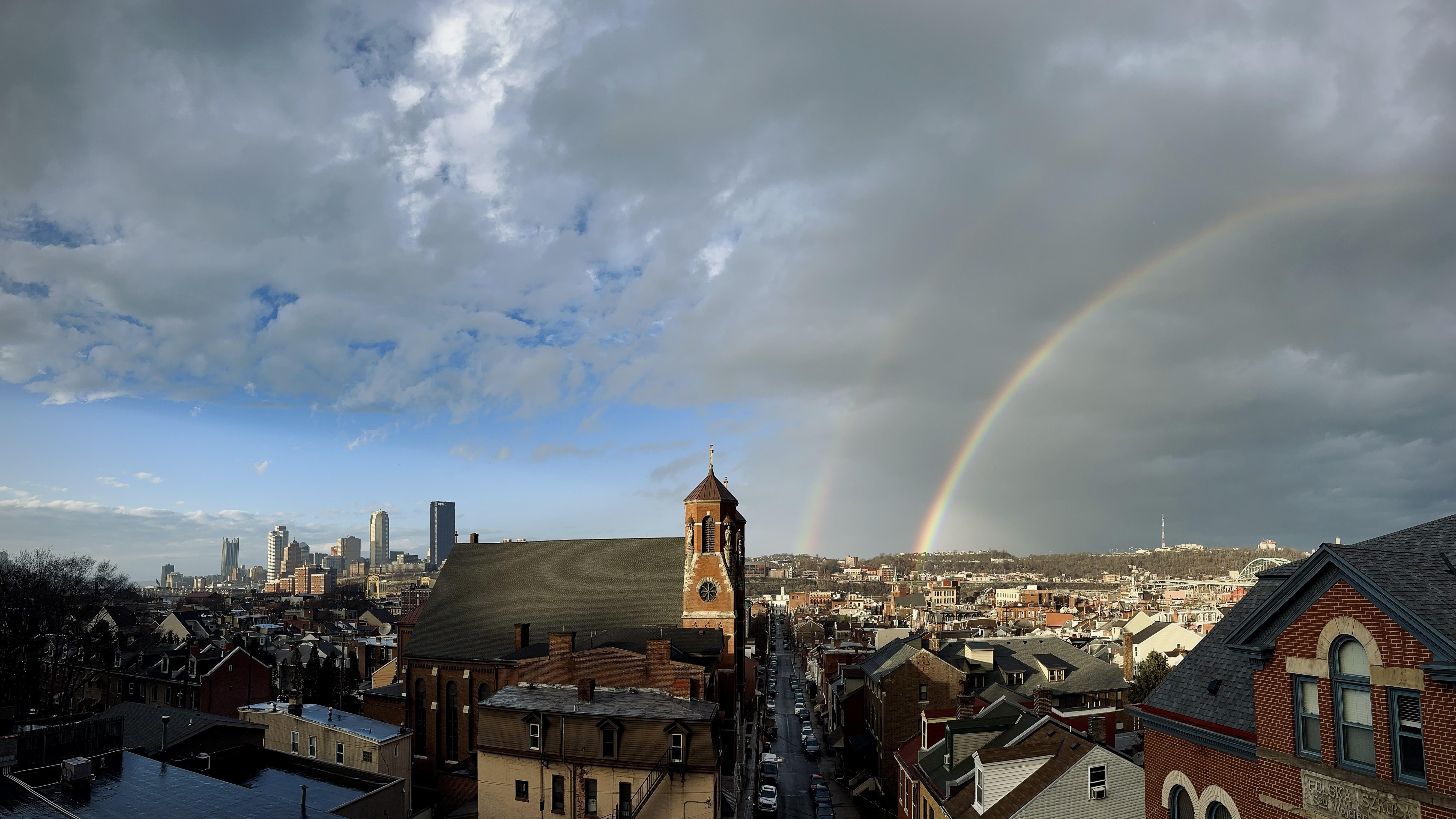 It was one of those "3 seasons in one day" days, but that's okay.
Submitted by ballsonthewall t3_10lduh1 in pittsburgh
ballsonthewall t1_j5u0two wrote
Reply to comment by vivamario in can someone meteorologically explain why snow is adverse to pittsburgh or does mother nature just not want to see us pgh skiers happy? by d071399
Pretty much, yeah!
ballsonthewall t1_j5thr1y wrote
Reply to comment by UnaffiliatedOpinion in Accuweather my ass! by [deleted]
the social media accounts for NWS Pittsburgh are great too!
ballsonthewall t1_j5tgufi wrote
Reply to comment by alakazampowdickmow in can someone meteorologically explain why snow is adverse to pittsburgh or does mother nature just not want to see us pgh skiers happy? by d071399
not really. what most people don't think of is that weather is 3D, rather than a plot of rain and snow on a 2D map. layers of warmer and colder air in the upper atmosphere are far more pertinent to what precip you see at ground level than anything happening on the surface. that's not to say small variations caused by local microclimates don't make a difference in observable weather, rather that they aren't going to change the whole metro area's weather like this dry slot did.
ballsonthewall t1_j5tgllr wrote
Reply to comment by Eco-freako in can someone meteorologically explain why snow is adverse to pittsburgh or does mother nature just not want to see us pgh skiers happy? by d071399
urban heat island wouldn't really have much impact until the snow is below radar levels anyways. snow might stick less downtown or vary slightly with elevation, but most of the dynamic weather is happening far enough up in the atmosphere to render small changes in what precip looks like at the surface moot.
ballsonthewall t1_j5tepbt wrote
Reply to comment by emeraldjalapeno in can someone meteorologically explain why snow is adverse to pittsburgh or does mother nature just not want to see us pgh skiers happy? by d071399
winter storms are insanely intricate and complicated, this thing dropped a foot of snow in Oklahoma and tornadoes in Texas at the same time yesterday. It's really cool to learn about them, but once you start, it's easy to understand why they're so hard to forecast... particularly here.
ballsonthewall t1_j5tbbpe wrote
Reply to comment by yourfavoriteyinzer in can someone meteorologically explain why snow is adverse to pittsburgh or does mother nature just not want to see us pgh skiers happy? by d071399
lmfao on any other day I wouldn't trust me, but when it comes to the weather I'm too big of a nerd to be anything but a straight shooter lol
ballsonthewall t1_j5tampn wrote
Reply to comment by Different-Rough-7914 in Accuweather my ass! by [deleted]
NWS is a much better source for weather. They're more willing to adjust as new data comes in. Forecasting winter storms is incredibly difficult and more about preparedness for a variety of outcomes than nailing down a single specific forecast.
ballsonthewall t1_j5t9xz2 wrote
Reply to can someone meteorologically explain why snow is adverse to pittsburgh or does mother nature just not want to see us pgh skiers happy? by d071399
Hi, since everyone else's comments are conjecture...
We are in a dry slot. Low pressure systems are often pulling in warm, moist air from the south and cool, dry air from the north as they develop and rotate. Pittsburgh is in a bad spot because often times the mountain ridges to our east will help facilitate pockets of air that is either too dry or too warm for snow.
I can't attach a picture, so here's a link with a nice illustration of a dry slot
ballsonthewall t1_j5pvjzp wrote
There's nothing unsafe about The Slopes, and some of the streets are insanely convenient to catch a bus over to Oakland. Be cautious of structural issues with houses here and be ready to deal with steep narrow streets and bad parking (though that applies to Greenfield as well!)
I adore my neighborhood and think it's a fantastic place to live with good access to many amenities and a really unique charm. I looked at places in both neighborhoods when I was buying a few years back. If you have more specific questions feel free to message me!
ballsonthewall t1_j5kjr3p wrote
Reply to Kristin Emery's snowfall charts ... WTF? by mckzach
Measured snowfall does not necessarily reflect what's left on the ground after the event is complete.
ballsonthewall t1_j5k2k0a wrote
This is an excellent bit of satire.
ballsonthewall t1_j5gm3vi wrote
Reply to Erie, Pa….I’m curious what is the perception of Pennsylvanians of Erie…it’s basically separated from the rest of the urban areas by Miserable-Gold-1493
It's like mini Detroit with a Pittsburgh theme lol
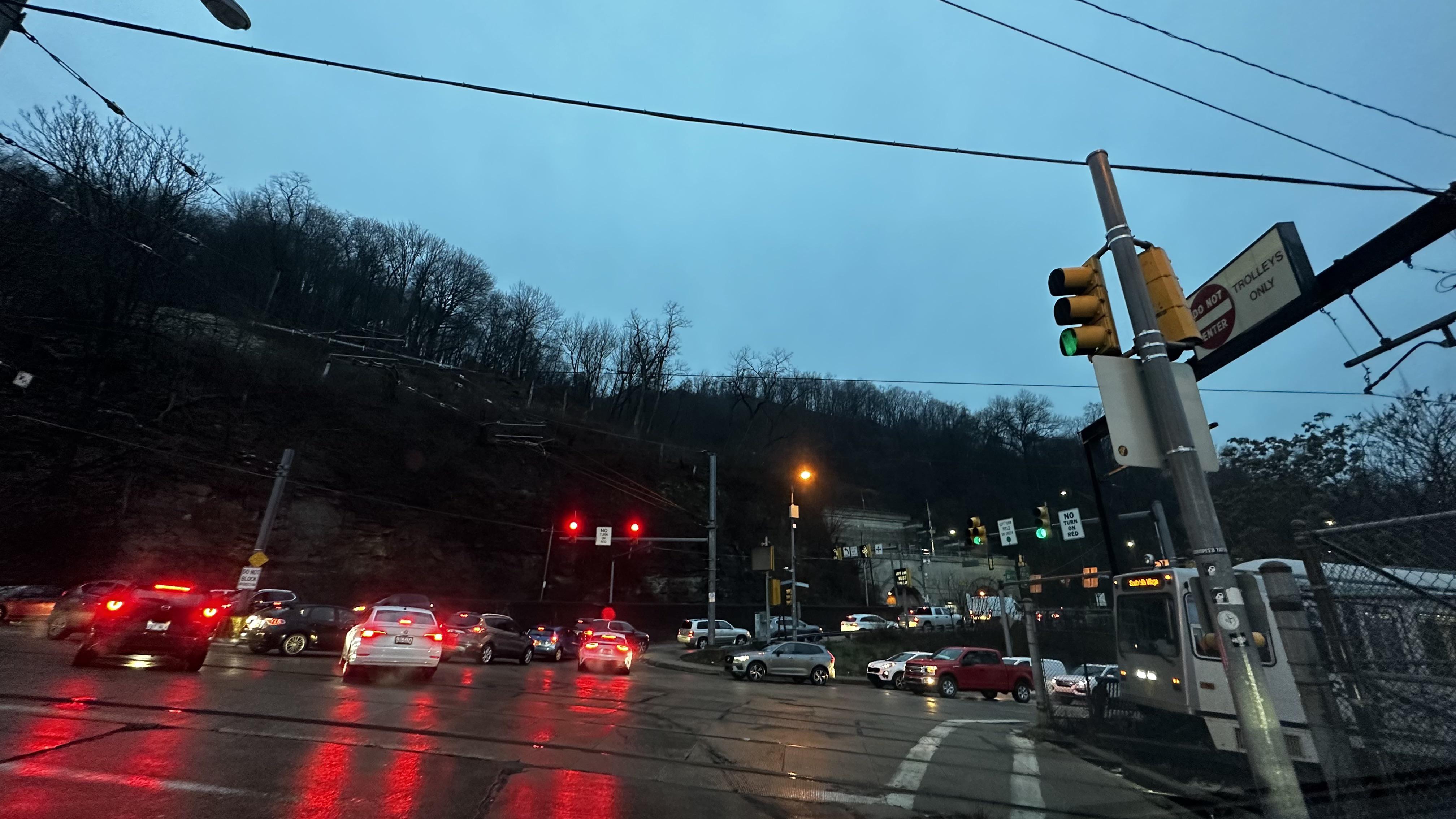 Blocking the intersection AND the T tracks, because you're the most important person on the planet (also, worst intersection in the city, hands down)
ballsonthewall t1_j3z4f1c wrote
Penn Ave Corridor downtown is great for bars and lounges. Con Alma is can't miss.
ballsonthewall t1_j2ei3sp wrote
Where are you located? I've really enjoyed watching sports at Sky Fox at the Highline. Nice TVs, good menu of snacks and food. It's a casual brewery atmosphere so you wouldn't be out of place not drinking.
ballsonthewall t1_j1sivvi wrote
Reply to comment by wonderfulwilliam in Sir, my turn signal was already on by lestgobuffaslug
It's a bunch of entitled fucks not from the city
ballsonthewall t1_j1mpr9i wrote
Reply to What better way is there to celebrate Christmas Eve then traveling the entire orange belt? by Majorkilljoy87
Good thing there's a sheetz along the way
ballsonthewall t1_j1948rf wrote
Reply to comment by DudeBroManGuyFellow in D oes anyone know of a weather forecasting website that will give me a "travel forecast" for a car trip? I absolutely have to drive a couple of hours northeast at some point today (mostly I79 and 80) and there's all sorts of weather conditions predicted. Thanks! by happyjazzycook
In the evening? Yeah you should be
ballsonthewall t1_j18lq8l wrote
Reply to comment by pinkpharmacist19 in D oes anyone know of a weather forecasting website that will give me a "travel forecast" for a car trip? I absolutely have to drive a couple of hours northeast at some point today (mostly I79 and 80) and there's all sorts of weather conditions predicted. Thanks! by happyjazzycook
take your time and you'll be fine by then, major roads will definitely be treated
ballsonthewall t1_j18k8v8 wrote
Reply to comment by pinkpharmacist19 in D oes anyone know of a weather forecasting website that will give me a "travel forecast" for a car trip? I absolutely have to drive a couple of hours northeast at some point today (mostly I79 and 80) and there's all sorts of weather conditions predicted. Thanks! by happyjazzycook
the front will pass in the morning hours, expect temps to drop through the 30's to near 0 from around 4 am to around 11 am. rain will change to snow and wind will gust to 50+ mph. traveling at that time will be dangerous to impossible. once things pass through and snow tapers off late morning, it's going to be cold and icy but manageable.
ballsonthewall OP t1_j61trqe wrote
Reply to comment by greenday5494 in It was one of those "3 seasons in one day" days, but that's okay. by ballsonthewall
I have pictures from all types of days and seasons there, beautiful vantage point